Publications Thomas Rühl
-
Tauchwellen-Tomographie für Stripping Korrekturen und geologische Interpretationen bei den reflexionsseismischen KTB-Profilen im Schwarzwald. Master Thesis (Diplomarbeit), University of Karlsruhe, Geophysical Institute. („Diving wave tomography for static corrections and geologic interpretations at the KTB 2D seismic survey line in the Black Forest“).
T. Rühl (1987) -
Near-vertical and wide-angle seismic surveys in the Black Forest, SW Germany. J. Geophys., 62: 1-30.
E. Lüschen, F. Wenzel, K.-J. Sandmeier, D. Menges, T. Rühl, M. Stiller, W. Janoth, F. Keller, W. Söllner, R. Thomas, A. Krohe, R. Stenger, K. Fuchs, H.Wilhelm and G.Eisbacher (1987) -
Near-vertical and wide-angle seismic surveys in the Schwarzwald. In R. Emmermann and J. Wohlenberg, editors, The German Continental Deeo Drilling Program (KTB), p. 297-362. Springer Verlag.
E. Lüschen, F. Wenzel, K.-J. Sandmeier, D. Menges, T. Rühl, M. Stiller, W. Janoth, F. Keller, W. Söllner, R. Thomas, A. Krohe, R. Stenger, K. Fuchs, H.Wilhelm and G.Eisbacher (1989) -
Oberpfalz deep seismic reflection survey and velocity studies. In R. Emmermann and J. Wohlenberg, editors, The German Continental Deeo DrillingProgram (KTB), p. 99-149. Springer Verlag.
J. Schmoll, R. Bittner, H.-J. Dürbaum, T. Heinrichs, R. Meißner, C. Reichert, T. Rühl and H. Widerhold (1989) -
Seismische Untersuchungen an der KTB-Lokation. KTB Report 89/1, DEKORP Report, p. 169-210.
U. Kästner, K. Bram, P. Hubral, W. Kiefer, C. Köninger, C. Macdonald, J. Merz, T. Rühl and K.-J. Sandmeier (1989) -
Inversion of first-break traveltime data of deep seismic reflection profiles. Geophysical Prospecting, 38, 3, 247-266.
T. Rühl and E. Lüschen (1990) -
Theoretische Grundlagen und praktische Anwendungen der Diffraktions-tomographie in der Geophysik. Doctoral Thesis (Dissertation), University of Karlsruhe, Geophysical Institute. (“Theoretical foundations and practical application of diffraction tomography in geophysics”).
T.Rühl (1991) -
Evalution and interpretation of VSP-measurements in the KTB-Oberpfalz pilot borehole. Scientific Drilling, 3, 89-99.
A. Hohrath, K. Bram, C. Hanitzsch, P. Hubral, U. Kästner, E. Lüschen, T. Rühl, P.K. Schruth and W. Söllner (1992) -
Migration of steeply dipping reflectors at the KTB site: Depth errors caused by inaccurate velocity models. KTB Report 92-5, DEKORP Report, 333-341.
C. Hanitzsch, P. Hubral., T. Rühl and W. Söllner (1992) -
Detection of permeable fracture zones by tube waves in the KTB pilot hole. KTB Report 92-5, DEKORP Report, 309-332.
C. Hanitzsch, T. Rühl and B.B. Heinemann (1992) -
Average and interval velocities derived from first breaks of vertical seismic profiles at the KTB pilot hole. KTB Report 92-5, DEKORP Report, 201-219.
T. Rühl and C. Hanitzsch (1992) -
Fourier finite-difference migration. Geophysics, 59, 12, 1882-1893.
D. Ristow and T. Rühl (1994) -
Determination of shallow refractor properties by 3D-CMP refraction seismic techniques. First Break, 13, 2, 69-77.
T. Rühl (1995) -
Fourier finite-difference migration for steeply dipping reflectors with complex overburden. Geophysical Prospecting, 43, 7, 919-938.
T. Rühl, C. Kopp and D. Ristow (1995) -
Frequency-space domain diffraction tomography in practical applications. Journal of Seismic Exploration, 5, 141-156.
T. Rühl and P. Hubral (1996) -
Finite-difference migration derived from the Kirchhoff-Helmholtz integral (Short Note), Geophysics, 61, 5, 1394-1399.
T. Rühl (1996) -
3-D implicit finite-difference migration by multiway splitting. Geophysics, 62, 2, 554-567.
D. Ristow and T. Rühl (1997) -
Optimized operators for 3-D Fourier Finite-Difference migration. Journal of Seismic Exploration, 6, 4, 367-383.
D. Ristow and T. Rühl (1997) -
Migration of the 3-D deep-seismic reflection survey at the KTB location, Oberpfalz, Germany. Tectonophysics 271, p 135-156.
M. Körbe, M. Stiller, H. Horstmeyer and T. Rühl (1997) -
Multi-attribute Bayesian risk modification –a case study from the Norwegian Barents Sea. First Break, 35, 1, 51-58.
T. Rühl and J. Samuelsson (2017)
Presentations Thomas Rühl
-
Inversion of first break traveltime data of seismic reflection profiles. 51st EAEG Meeting and Techn. Exhib., Berlin, Germany. Abstracts, p. 192.T. Rühl, E. Lüschen (1989)
-
Combined VSP-and surface reflection seismic investigations at the KTB drilling site, Upper Palatinate, F.R.G.. 51st EAEG Meeting and Techn. Exhib., Berlin, Germany.Abstracts, p. 193-194.P. Hubral, U. Kästner, C. Macdonald, T. Rühl and K.-J. Sandmeier (1989)
-
Two case histories of diffraction tomography applied in engineering geophysics. 53rd EAEG Meeting and Techn. Exhib., Florence, Italy.Extended Abstracts, p 456-457.T. Rühl and B. Illich (1991)
-
Determination ofshallow refractor properties by 3D-CMP refraction seismic techniques. 55th EAEG Meeting and Techn. Exhib., Stavanger, Norway.Extended Abstracts, B010.T. Rühl (1993)
-
Cascading phase-shift and finite difference operators for downward continuation. 55th EAEG Meeting and Techn. Exhib., Stavanger, Norway.Expanded Abstracts, Session: C044.D. Ristow and T. Rühl (1993)
-
Extended split-step migration by cascading phase-shift and optimized finite-difference operators. 63rd Annual Meeting , Soc. Explor. Geophys., Washington, DC, USA.SEG Technical Program Expanded Abstracts, 986-989.D. Ristow and T. Rühl (1993)
-
Fourier FD migration for steeply dipping reflectors with complex overburden. 56th EAEG Meeting and Techn. Exhib., Vienna, Austria.Expanded Abstracts, Session P100.T. Rühl, C. Kopp and D. Ristow (1994)
-
Deviated-borehole diffraction tomography in the frequency-space domain. EAGE 57th Conf. and Techn. Exhib., Glasgow, Scotland.Expanded Abstracts, Session P132.T. Rühl (1995)
-
3-D implicit finite-difference migration by multi-waysplitting. 65th Annual Meeting, Soc. Explor. Geophys., Houston, USA.SEG Technical Program Expanded Abstracts, 1220-1223.D. Ristow and T. Rühl (1995)
-
Fourier FD migration: The missing link between phase-shift and FD migration. 65th Annual Meeting , Soc. Explor. Geophys., Houston, USA.SEG Technical Program Expanded Abstracts, 1232-1235.T. Rühl and D. Ristow (1995)
-
Optimized operators for multi-way split 3D Fourier Finite-difference migration. 58th EAGE Conf. and Techn. Exhib., Amsterdam, The Netherlands.Expanded Abstracts, Session: P094.T. Rühl and D. Ristow (1996)
-
Can we image complex structures using smoothed macro-velocity models? 66th Annual Meeting , Soc. Explor. Geophys., Denver, USA.SEG Technical Program Expanded Abstracts, 543-546.S. Clar, N. Ettrich and T. Rühl (1996)
-
Reducing anisotropy and frequency dispersion by 3-D Fourier finite-difference migration. 66th Annual Meeting , Soc. Explor. Geophys., Denver, USA.SEG Technical Program Expanded Abstracts, 471-474.D. Ristow and T. Rühl (1996)
-
3-D imaging of steeply dipping reflectors within a complex crystalline crust: Case study of KTB-ISO89 3-D survey. 66th Annual Meeting , Soc. Explor. Geophys., Denver, USA.SEG Technical Program Expanded Abstracts, 531-534.
T. Rühl (1996) -
Migration in transversely isotropic media using implicit operators. 67th Annual Meeting , Soc. Explor. Geophys., Dallas, USA.SEG Technical Program Expanded Abstracts, 1699-1702.
D. Ristow and T. Rühl (1997) -
Evaluation of the Snorre amplitude anomaly. 62nd EAGE Conference, Glasgow. Expanded Abstracts, Session X0023.J.E. Battié, S. Anderson, T. Kolien, T. Rühl and E. Toivakka (2000)
-
Cretaceous-Paleogene prospectivityof the German North Sea. DGMK Frühjahrstagung 2001, Celle, Germany.T. Rühl, O. Tveiten, G. Berg, E. Toivakka, E. Holden, M. Weldon, M. Trayfoot (2001)
-
Temperature-dependent seismic velocities of poorly consolidated sandstones –application to AVO analysis of low-viscosity oil reservoirs. SEG Summer Research Workshop, 20-24 July, 2008, Galway, Ireland.T. Rühl (2008)
DR. THOMAS RÜHL
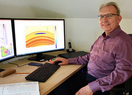
Thomas is owner and chief geophysicist of Amisia GeoConsultants. He studied geophysics at Karlsruhe University in Germany, where he also made his doctoral thesis (Ph.D.). From 1987-1997, Thomas worked in academia, mainly on reflection seismic inversion and migration algorithms. Since 1997, he works in the oil and gas industry at various companies. His field of expertise is seismic reservoir characterization (SRC) or Quantitative Interpretation (QI). At Amisia GeoConsultants, Thomas is responsible for all geophysical SRC projects and topics.
-
2019-Amisia-GeoConsultants in Lingen (Germany); Chief Geophysicist, seismic reservoir characterization projects
-
2018-2019Neptune Energy in Lingen; Senior Geophysicist, seismic reservoir characterization projects for German and international assets
-
2003-2018Gaz de France, GDF Suez, ENGIE in Lingen; Senior Geophysicist, seismic reservoir characterization projects for German and international assets
-
2001-2003Preussag Energie in Lingen; Senior Geophysicist, seismic processing and reservoir characterization projects
-
1997-2001Petroleum GeoServices (PGS) in Oslo (Norway); Principal Geophysicist, seismic reservoir characterization projects for clients of PGS Reservoir AS/PGS Reservoir Consultants AS
-
1992-1997GEOMAR research centre at Kiel University (Germany); Scientific employee, research on new migration algorithms (Fourier FD), supervision of students, lectures
-
1991Dissertation / doctoral thesis about diffraction tomography
-
1980-1987University studies (geophysics, geology) at Karlsruhe Technical University (Germany) and Technical University (ETH) of Zurich (Switzerland)
-
1979-1980Military service
-
1966-1979Primary and secondary school
-
1960Born at Siegen (Germany)
International E&P projects and experience


UTA RÜHL
Team


Dr. Thomas Rühl

Cooperations / Partners
We can use all commercial plugins of dGB and third parties, offered in the software portfolio of OpendTect Pro. Collaborative project proposals in dGB style and format will be submitted. A significant part of the work will be carried out at Enschede under supervision of dGB’s experts. This ensures that the high quality standards of dGB will be met.
Please find more information about dGB's software:

We cooperate with Terra Geoservice, a recently founded independent German consulting company offering geoscientific services for the oil & gas industry, storage management, geothermal exploration and nuclear waste disposal. An expert team of geologists, geophysicists and petrophysicists is available for integrated project solutions.
Please find more information about Terra Geoservice GmbH:
Infrastructure: hardware and software
In order to run your projects, we have installed a powerful hardware, so that we can tackle also mid-size 3D seismic surveys for pre-stack inversion and AVO analysis.
Project archiving is very important. We make sure that we run continuous back-ups and hold archives at two distinct locations.
On the software side, our philosophy is to choose the software which is best suited for each individual project.
- TERRA 8600 power workstation with
- 2 Intel Xeon Gold 5222, 4 cores CPUs, 3.8 GHz,
- RAM 128 GB,
- graphic card NVIDIA Quadro RTX 4000, 8GB
- 1 SSD PCIe 2TB fast internal disc and
- 1 HDD 4TB internal disc.
- STRATA Plus (GeoSoftware, formerly CGG Hampson Russell)
- OpendTect Pro with all available commercial plugins, due to our collaboration with dGB Earth Sciences
- IP petrophysical software (Lloyd's Register, formerly Senergy)
- Seismic Spectral Blueing SSB (ARK CLS)
- EMERGE, ISMAP, AVO, RockSI, LithoSI software modules from CGG- Hampson Russell (neural network and geostatistical analysis, AVO, rock physics and lithology classification)
- RokDoc 1D/2D (rock physics) and reservoir characterization/seismic inversions from company IkonSciences
- Interwell and EasyTrace (seismic inversion), from company BeicipFranlab
- InverTrace Plus and RockTrace (seismic inversion), from CGG-Jason
- Paradise (multi-attribute seismic analysis), from company Geophysical Insights

What is Amisia?
Amisia-GeoConsultants are based in the small beautiful town of Lingen, in the Emsland region of Northwest Germany, close to the Dutch-German border. The Emsland and the Grafschaft Bentheim to its west straddles the western part of the prolific Lower Saxony oil and gas basin. For a long time, the oil field Rühlermoor was the largest onshore German oilfield (see picture of oil field at peat production area). This field and many other small-scale oil and gas fields are still producing until now.
Our name Amisia refers to the Latin name of the river Ems, which is meandering through a lovely landscape. About 2000 years ago, from 12 BC until 16 AD, the Romans under emperor Augustus tried to conquer the western area of Germania Magna, one part of which is the Emsland. Some sources say that the famous Roman commander Germanicus came up the river Amisia (Ems) together with his soldiers in summer 15 AD, starting from a military base at the mouth of the Amisia, at the North Sea, near the modern town of Emden. All this happened after the campaign of commander Varus suffered a disastrous defeat at the battle of Teutoburg in 9 AD. The Romans never succeeded to conquer this free part of Germania and make it a part of the huge Roman Empire.
Contact
Amisia-GeoConsultants
Am Holländerberg 3
D-21465 Reinbek
Germany

